GENERAL STATISTICS AND KEY FIGURES OF ALGERIA
Everything you need to know about Algeria
- Area: 2,381,741 km² – roughly four times the size of France.
- The country presents itself as an immense desert landscape.
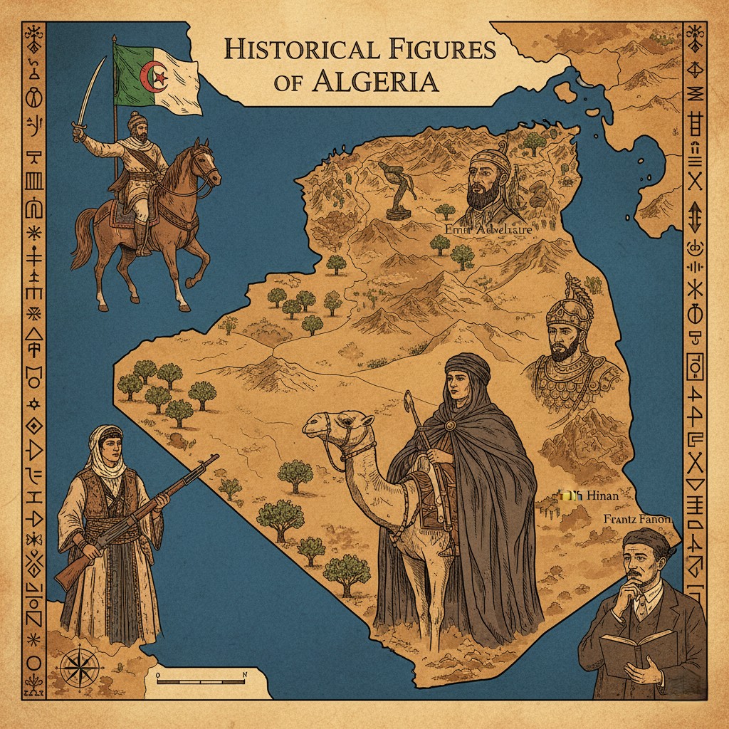
- Located at the heart of the great epochs that have shaped the Mediterranean, Algeria has been a beacon of liberty, unity, and progress since the Numidian kingdom, through the Islamic conquests, and throughout colonial wars, while also forging democratic and prosperous states during its times of greatness and peace.
The Turning Point: 1 November 1954
- This date marks a pinnacle of Algerian destiny – the culmination of a long struggle against assaults on its culture, values, and the core pillars of its identity: Islam, Arab identity, and Amazigh heritage.
- 1 November firmly anchored the present struggles in the glorious past of the nation.
THE NORTHEASTERN REGION – LESS THAN ONE‑SIXTH OF THE TERRITORY
It is composed of three parallel zones along the coast, extending from north to south:
- The Tell Atlas
- A 1,000 km long and 125 km wide chain between the sea and the high plains.
- It includes the Mounts of Tlemcen, the Ouarsenis, the Mounts of the Algerian Sahel, the Djurdjura Massif (home to Lalla Khadidja, its highest peak at 2,308 m), and the Constantine Massif.
- Interlacing Valleys and Plains
- The Sig plain, the Ouled Chélif valley, the Mitidja plain south of Algiers, the coastal plain of Annaba drained by the Seybouse River, the high plains of Sétif and Constantine (through the Rummel River), the high plateaus – vast steppe areas with depressions such as the Chotts el‑Chergui and el‑Hodna.
- The Saharan Atlas
- A succession of mountains: the Ksour Massif (1,200 m), Djebel Amour, the Ouled Naïl Mountains (1,500 m), the Aurès, and the Ziban.
THE DESERT – 2 MILLION km² OF VAST, DRY LAND
- Dominated by dry valleys like the Ouled Saoura, the vast sand seas of the Grand Erg Occidental and the Grand Erg Oriental, plateaus such as Tademaït, Tas‑sili, and Tanezrouft, and mountains like the Hoggar (a volcanic massif with its peak, Tahat, at 3,010 m).
CLIMATE
Diverse climatic zones range from Mediterranean to Saharan.
- North: Winters are rainy and cool; summers hot and dry. The coastline’s climate is moderated by the sea.
- Eastern Algeria: Receives more rainfall than the west, averaging 2 m per year, with snowy peaks from October to July.
- Southern Foot of the Tell Atlas: Marks the boundary of an arid climate – dry and tropical – with wide temperature swings: average daytime temperatures around 36 °C and nighttime lows of 5 °C.
The North – A Land of Highlands
- The north is mainly Mediterranean, tempered by a continental influence due to the coastal chains acting as a barrier to maritime effects.
- The further inland, the more pronounced the Mediterranean–continental blend becomes.
- Winters are harsh; summers are hot and dry.
- Precipitation is scant and irregular – scarce in summer, more frequent in winter in the Tell region, and in spring on the high plateaus.
- The eastern Tell and the high plains of Constantine receive abundant rainfall, while the south of the Aurès and the Ouara high plains are comparatively drier.
The South – The Desert Dominated by the Hoggar
- Annual precipitation is less than 1,500 mm.
- Daytime temperatures soar; nighttime temperatures plunge to 0 °C.
- Soil aridity is extreme.
A GLOBAL GREETING FROM ALGERIA
Friends of Algeria around the world – and fellow Maghrebis – I present you a dedicated space about Algeria so that you can learn more about this nation. I wish to dedicate it to a friend who is very dear to me, someone more than just a friend. I will show you your country in my own way.
HISTORY OF ALGERIA
| Year | Event |
|---|---|
| 647 | First Arab incursions and Islamisation of the Maghreb |
| 720 | Revolt in the Aurès (Kahina uprising) |
| 761 | Ibn Rostem founds the Tahert kingdom (Iadite) |
| 800‑909 | Aghlabid Kingdom |
| 911 | The Fatimids destroy the Iadite kingdom |
| 973 | Fatimids hand power to the Sanhaja tribe (Zirid dynasty) |
| 1152 | Almohad Kingdom |
| 1509 | Oran captured by the Spanish |
| 1514 | Brothers Aroudj and Khayr‑eddin (Barberousse) become masters of Algiers |
| 1518 | Ottoman protectorate |
| 1587 | Transformation of Algeria into a Regency |
| 1830 | Beginning of French colonisation |
| 1839‑1847 | Resistance of Abd al‑Kader |
| 1870 | Kabyle revolt against French presence |
| 1945 | Nationalist demonstrations in Constantine |
| 1954 | (1 Nov) FLN launches the War of Independence |
| 1962 | (5 July) Independence |
| 1962 | (Sept.) Ahmed Ben Bella elected President |
| 1965 | (19 Jun.) Ben Bella overthrown by the Revolutionary Council, led by Houari Boumédiène |
| 1971 | (Feb.) Nationalisation of oil |
| 1978 | (27 Dec.) Death of Houari Boumédiène |
| 1979 | (7 Feb.) Chadli Bendjedid becomes President |
| 1988 | (Oct.) Popular protests (especially youth), violently repressed |
| 1990 | (12 Jun.) Municipal elections – FIS (Islamic Salvation Front) wins |
| 1991 | (26 Dec.) First round of legislative elections – FIS poised to gain majority |
| 1992 | (Jan.) President Bendjedid resigns; High State Council (HSC) established; elections suspended |
| 1992 | (4 Mar.) FIS dissolved; conflict between the state and Islamists begins |
| 1992 | (29 Jun.) HSC President Mohammed Boudiaf assassinated |
| 1994 | (31 Jan.) Liamine Zeroual, backed by the HSC, becomes head of state – end of HSC rule |
MONUMENTS, HISTORY, AND MOSQUES IN ALGERIA
Algeria sits at the crossroads of three worlds – Mediterranean, Islamic, and African – and is a cradle of art and civilisation. It offers a varied landscape of regions and cities, each uniquely shaped by its natural environment, history, and cultural identity.
The Great Mosque of Tlemcen
- Located in the city centre, its architectural proportions are regular and its overall harmony striking.
- Eight entrances grant access.
- Occupying roughly 3,000 m², it earned its name from the vastness of its structures.
- Built circa 1102 by Youcef Ibnou Tachfine, founder of the Almoravid dynasty, it originally showcased austere asceticism. In 1136, Ali Ben Youcef enlarged the mosque, enhanced the primitive minaret, the mihrab, the central niche, and added a dome in front of the mihrab.
Oran – A City Rich in Historical Remains
- Flourished under the Almohads and the Zayyanids of Tlemcen.
- Its port shared maritime traffic with Rachgoun and Honaïne.
- Occupied by the Spanish for nearly three centuries (expedition led by Pedro Navarro in 1509), their influence is evident in some monuments.
- In 1791, a devastating earthquake (2,000 victims) and attacks by the Bey of Mascara prompted King Charles III of Spain to negotiate the surrender of Oran with the Dey of Algiers.
- A stroll through the old town reveals layers of Spanish, Turkish, and French influence, each telling a page of Oran’s long and tumultuous history.
- Highlights include:
- Mosque Ben Othman
- Mosque of the Pasha Sidi El Houari
- Cathedral
- Synagogue
- The Palace of the Bey of Oran – former residence of six Beys, the last being Bey Hassan.
- Barberousse’s house, now a Museum of Popular Arts, and other palaces in the Casbah, reflecting the refinement of its inhabitants.
- Numerous other Algerian mosques.
The Mosque of Ketchaoua
- The Casbah – a fortress‑like district that remained intact yet was never fully integrated into the modern city.
- An Alger that existed in the 16th–18th centuries, not the cardboard‑cutout of films, but the authentic Orientalist prints, the city as seen by Charles V before being bombed, and as represented by Hadj Ahmed Bey in his Constantine palace.
- The walls may have vanished, but the illusion remains strong.
The Casbah’s Terraces
- The Casbah architecture is embodied in charming houses and picturesque villas, arranged logically and well suited to the inhabitants’ habits.
- The essential feature is the square central patio, surrounded by four galleries, each opening onto spacious, deep rooms.
- These two‑ or three‑story houses are covered by terraces.
Constantine – The Old Town
- Minarets and porches with polychrome decorations denote religious buildings, most of which date to the Turkish era, except for the Djamaa el‑Kebir (Great Mosque), built in the 13th century.
- Nearby, boulevard Larbi Ben M’Hidi overlooks a pedestrian bridge; an old medresa, now an office of the university, is adorned with polychrome ceramic tiles.
POPULATION
The People of Algeria – A Historical Overview
At the dawn of recorded history, Algeria was inhabited by Berbers, also known as Libyans or Amazighs. Some were nomadic, others sedentary, and they possessed writing (characters similar to the current Tuareg Tifinagh), drawing, and modest, evolved burial customs (Bazina).
In its earliest state organization, Algeria was called Numidia, governed by successive Berber kings from Syfax to Juba II.
From Phoenician Settlements to Roman Rule
- By the 12th century BCE, Phoenicians had established coastal colonies, which shaped a region destined for trade and universal connections.
- After Carthage’s destruction (146 BCE) and Rome’s victory over the Numidian kingdoms, northern Algeria became part of the Roman Empire’s African provinces.
- Archaeological remains—military towns of Timgad and Lamba, the beautiful and gentle Djemila near Sétif, and coastal residences such as Tipaza—hold a significant place in Algeria’s cultural heritage.
Arab Conquest and Ottoman Regency
- In the 7th century, Arab conquest began, leading to a definitive Islamisation.
- The 16th century saw the establishment of the Turkish Regency, bringing a maritime history enriched by legend.
Current Demographics
- Population (circa 1999): ~30 million inhabitants.
- Distribution: The majority live in the north along the coast.
- Growth: Tripled between 1962 and 1999; the high fertility rate (once 3.4 % per annum) fell to 1.6 % by 1998.
- Marriage Age: Now an average of 25 years for women and 30 years for men, with a significant decline in fertility rates.
- Life Expectancy: About 70 years.
- Health Coverage: Reasonably good, with one doctor per 1,100 inhabitants.
- Households: Approximately 4.5 million; over 70 % of Algerians own their homes.
- Occupancy: Very high – about 7 persons per dwelling.
- Housing Construction: Roughly 150,000 new homes commence construction annually over the past five years.
End of Translation and Enhancement.


